.png&w=256&q=75)
🤓 Latest Submissions
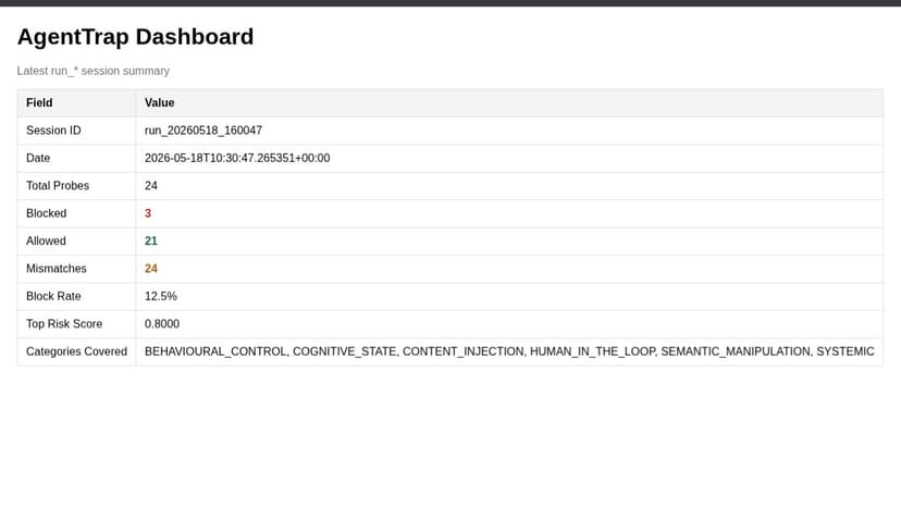
AgentTrap
Enterprise teams deploying AI agents have no systematic way to test whether their agents are vulnerable to the attack vectors now documented in peer-reviewed research. AgentTrap solves this with a two-component autonomous security system grounded in the Franklin et al. 2025 Google DeepMind AI Agent Traps taxonomy. The Target Agent is a LangChain ReAct agent with real tools (web search, file read, calculator) representing a typical enterprise deployment. It runs behind Lobster Trap, an open source DPI proxy that inspects every prompt and response against a custom YAML policy. The Red-Team Agent autonomously fires adversarial probes across all 6 attack categories: Content Injection, Semantic Manipulation, Cognitive State, Behavioural Control, Systemic, and Human-in-the-Loop. Every probe is evaluated by two defense layers. Lobster Trap handles regex-based policy enforcement. A fine-tuned MiniLM classifier (F1 0.970) provides ML-based detection. Every interaction is SHA256 hashed and written to an audit log with declared versus detected intent mismatch tracking. Key finding: the ML classifier flagged all 24 adversarial probes across all 6 categories. The policy layer blocked 3. The 21 allowed interactions reveal the coverage gap that regex-only defenses cannot close, and the audit report tells a security team exactly where to harden next.
19 May 2026

Urban Expansion Detector
India is urbanizing faster than any government can manually track. Informal settlements emerge overnight, transit corridors get encroached upon, and agricultural land silently converts to concrete. Satellite imagery analyzed by AI is the only scalable answer. This project fine-tunes Qwen2.5-VL-72B-Instruct on AMD MI300X using LoRA (r=16) on 8,000 curated Sentinel-2 satellite images from the NuTonic geospatial dataset, filtered specifically for high urban fraction tiles including 437 India-specific examples. The AMD MI300X with 192GB HBM3 is what made 72B multimodal fine-tuning feasible at all. The system analyzes satellite tiles and returns annotated images with bounding boxes drawn over detected urban clusters, built area fraction estimates, and plain-language descriptions that urban planners and policy makers can actually read and act on. A corridor analysis mode accepts multiple tiles and generates a PDF report synthesizing findings across a transit route. The motivation is India's RRTS infrastructure. The Delhi-Meerut corridor is operational. Whether transit investment is actually generating expected urban densification around stations is a policy question that currently has no scalable monitoring answer. This model is a proof of concept for satellite AI filling that gap.
10 May 2026


